Heat wave predicted to subside in the next week
Published 3:05 pm Saturday, June 25, 2022
By Skip Rigney
Pick your adjective. Sizzling. Scorching. Sweltering. I’m a simple man, so I’ll go with really hot.
You might protest that, “Well, of course, it’s hot. It’s June and we live in south Mississippi.” But, even by south Mississippi standards, we are in the midst of a significant heat wave.
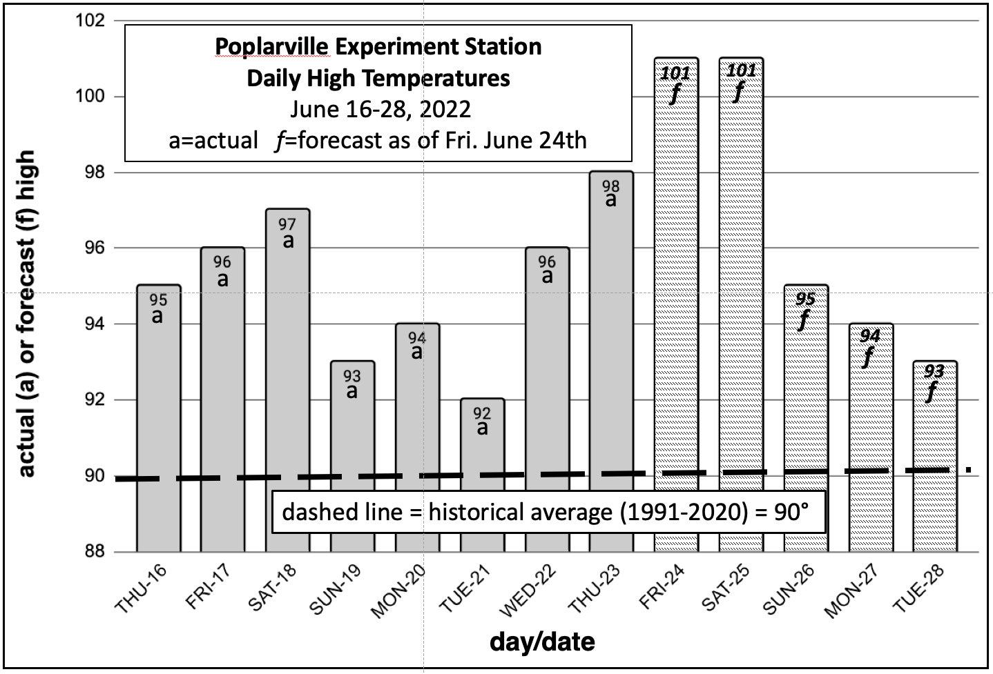
The normal, by which I mean 30-year historical average, daily high temperatures for middle and late June in Pearl River County are right around 90 degrees. It has been hotter than that at Mississippi State University’s South Mississippi Branch Experiment Station in Poplarville every afternoon since June 12th. Although no records were broken in Poplarville, this graph of daily high temperatures shows that since June 16th the high temperature has been two to eight degrees hotter than normal every day.
As of Friday morning, many official federal weather observing stations in our local region had hit 100 degrees or higher on at least one day during the past week: Slidell – 100 (Wednesday, Thursday). Bogalusa – 100 (Saturday, Wednesday, Thursday). Gulfport – 101 (Saturday, Thursday). Hattiesburg – 102 (Wednesday, Thursday).
Heat waves are not isolated, local phenomena but are associated with large sprawling areas of high pressure in the middle altitudes of the atmosphere. So, it’s not surprising that some of our regional neighbors have been sharing in the sauna. New daily records were set in Mobile last Saturday (101), Wednesday (101), and Thursday (102). Memphis, not to be outdone, also hit triple digits on two days. Meridian set new records on Wednesday and Thursday of 103 and 102.
Friday afternoon’s high temperatures weren’t yet available when this article went to press, but it could easily turn out to be our hottest day of the heat wave in Pearl River County. And, Saturday won’t be far behind.
Fortunately, forecasters expect the heat to ease over the southern United States beginning Sunday into the upcoming week as the hot bubble of high pressure several miles above us finally begins to break down. That will allow significantly more clouds and showers to form each day beginning Sunday and continuing through most of the upcoming week. In other words, a return to typical summer heat, humidity, and showers.

